


- HOME
 ☆ XXL SALE ☆
- CLOTHING
- SHOES
- SPORTS
 Climbing
- Ascenders
- Crash pads
- Ice Axes
- Quickdraws
- Nuts & climbing friends
- Belay devices
- Carabiners
- Pulleys
- Ropes
- Climbing sets
- Climbing Shoes
- Crampons
- Chalk & chalk bags
- Clothing
- Anchors & bolts
- Technical climbing gear
- Helmets
- Slackline
- Loops
- Ice screws
- Training boards
- Harnesses
- Rope bags
- Descender brakes
- ...show all
 Via Ferrata
 Hiking
 Camping
 Running
 Ski Touring
- EQUIPMENT
- Work & safety gear
- SPECIAL OFFER































 adamsport.store
 adamsport.store
 adamsport@adamsport.e
TM 5004 Low Tatras - East 1:50,000
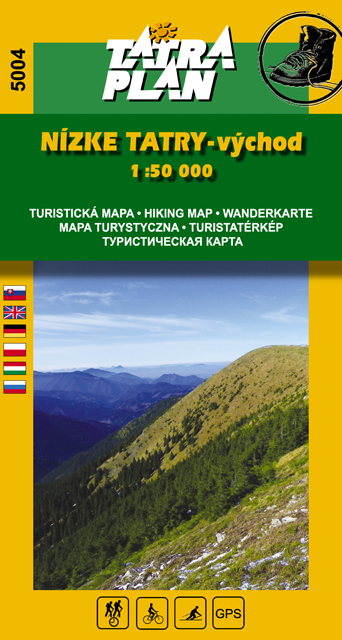
TM 5004 Low Tatras - East 1:50 000 - SK, GB, PL
Tourist and cycling map at a scale of 1:50 000 with text part in Slovak, English and Polish
Hiking and cycling map at a scale of 1:50 000 in Slovak-Polish-English language version. It shows the whole ridge of the eastern part of the Low Tatras from Telgárt to Čertovica. The map is an invaluable aid in an attractive ridge walk. EAN 9788089349258, publ. TATRAPLAN s.r.o.
You can also find similar products here:
Manufacturer:Tatraplan
Your price: 5,00 €
5,54 €
Save 10 %
Availability
Availability: In stock
Legal guarantee 2 years (EU notice)
Show information

EXPRESS DELIVERY via GLS and Packeta
VERIFIED SHOP more than 12 years of skills
GUARANTEED the lowest prices
Výmena tovaru zdarma pre oblečenie a obuv nad 160 €
Pri objednávke oblečenia a obuvi, s hodnotou viac ako 160 € ti poskytneme výmenu tovaru zdarma a veľmi rýchlo.
CUSTOMER SERVICE we are here for you
Customer service we are here for you
Ohľadom tohto produktu ti poradí: Patrik 0917 225 882
You can also find similar products here:
Recently viewed

Availability
Availability: In stock
5,54 €
5,00 €
Save 10 %
Subscribe to our newsletter and keep up with the latest offers and trends
Five reasons to shop at ADAMSPORT.STORE
|
Express delivery |
Verified shop |
Guaranteed |
Customer service |
Our local store |


Contact us
Store adress:
| iMi Trade s.r.o. Jánošíkova 21 010 01 Žilina |
Slovakia
adamsport@adamsport.store

VAT: 31 565 531
VAT ID: SK2020445416

Share your opinion with others
Add reply to comment: