
- HOME
 ☆ XXL SALE ☆
- CLOTHING
 -Men's clothing
- Jackets
- Hoodies
- T-shirts
- Thermal underwear
- Shirts
- Vests
- Pants
- Short Pants
- Men's cycling clothing
- Men's overalls
 -Women's clothing
- Jackets
- Sweatshitrs
- Skirt
- T-shirts
- Thermal underwear
- Bras
- Vests
- Pants
- Shorts
- Cycling apparel
 -Clothing - Accessories
- Sunlasses
- Headbands
- Caps
- Baseball caps
- Multifunctional scarves
- Gloves
- Socks
- Impregnation
- Compression sleeves
- Hoods
- Belts
- Raincoats
- Other Accessories
- SHOES
 -MEN'S SHOES
- High hiking boots
- Low hiking shoes
- Running shoes
- Leisure Shoes
- Climbing Shoes
- Fivefingers shoes
- Winter boots
 -WOMEN'S SHOES
- High hiking boots
- Low hiking shoes
- Running shoes
- Leisure Shoes
- Climbing Shoes
- Women's Fivefingers shoes
- Winter shoes
 -ACCESSORIES
- Impregnation
- Gaiters
- Anti-slip crampons
- Shoelaces
- Shoe insoles
 -Men's shoes sale
 -Women's shoes sale
- SPORTS
 -Climbing
- Ascenders
- Crash pads
- Ice Axes
- Quickdraws
- Nuts & climbing friends
- Belay devices
- Carabiners
- Pulleys
- Ropes
- Climbing sets
- Climbing Shoes
- Crampons
- Chalk & chalk bags
- Clothing
- Anchors & bolts
- Technical climbing gear
- Helmets
- Slackline
- Loops
- Ice screws
- Training boards
- Harnesses
- Rope bags
- Descender brakes
- ...show all
 -Via Ferrata
- Sets
- Kids via ferrata equipment
- Carabiners
- Shoes
- Helmets
- Gloves
- Damper falls
- Harnesses
- ...view all
 -Hiking
- Hiking shoes
- Clothing
- Backpacks
- Ice axes
- Travel first aid kits
- Water filtration
- Bottles
- Strike igniters
- Heaters and warm patches
- Anti-slip crampons
- Snowshoes
- Food and nutrition
- Vacuum flasks
- Hiking maps
- Hiking guides
- Hiking Gaiters
- Trekking poles
- Survival gear
- Accessories
- ...view all
 -Camping
- Tents
- Sleeping bags
- Sleeping pads
- Hammocks
- Cartridges
- Spice jars
- Camping Furniture
- Camping Cookware
- The mosquito
- Protective creams
- Cutlery
- Repellents
- Cookers
- Camping preferred sets
- ...view all
 -Running
- Running shoes
- Clothing for runners
- Running gear
- Drinks and gels
 -Ski Touring
- Sets
- Skis
- Boots
- Skins
- Bindings
- Avalanche safety
- Clothing
- Backpacks
- Poles
- Gear
- Equipment
- Accessories
- ...view all
- EQUIPMENT
 -Baby carriers
- Carriers up to 20 kg
- Carriers up to 22 kg
- Accessories
- Bargain Sets
 -Backpacks
- Small Backpacks to 29 l
- Medium backpacks 30 - 55 l
- Large backpacks 55-90 l
- Hydration systems
- Pouches
- Waistpacks
- Wallets
- Raincovers
- Dry bags & waterproof cases
- ...view all
 -Light sources
- Headlamps
- Flashlights
- Accessories
 -Tents
- For 1-2 persons
- For 3-4 persons
- For 4 and more persons
- Cotton
- Expedition
- Waterproof
- Party tents
- Beach
- Shelters
- Festival
- For motorcyclists
- Ultralight
- Tent accessories
- ...view All
 -Sleeping bags
- Kids
- Summer
- Three-season
- Winter
- Bivy bags
- Rectangular
- Small and lightweight
- Down
- By temperature limit
- Accessories
- ...view All
 -Sleeping pads
- Foam
- Self inflatable
- Inflatable
- Air mattresses
- Accessories
 -Work & safety gear
- Work at height equipment
- Arboriculture
- Rescue work
- Armed forces
- Rope parks
- ...view all
 -Tools
- Knives
- Gerber knives
- Machetes
- Multifunction Tools
- Saws
- Axes
- Work & safety gear
 -Work at height equipment
- Ascenders
- Headlamps
- Carabiners
- Anchoring devices
- Pulleys
- Lanyards
- Harnesses
- Helmets
- Positioning devices
- Loops
- Static ropes
- Fall arresters
- Descender brakes
- Qccessories
 -Arboriculture
- Descenders
- Harnesses
- Pulleys
- Installing the rope in the tree
- Lanyards for tree care work
- Accessories
 -Rescue work
- Rescue systems
- Rescue and transport equipment
- Stretchers
 -Armed forces
- Harnesses
- Ropes
- Helmets
- Pulleys
- Ascenders
- Carbines
- Descender brakes
 -Rope parks
- Full-body harnesses
- Pulleys
- Helmets
- SPECIAL OFFER
- BRANDS
- Acron
- Adam Sports
- Adidas
- Adventure Menu
- Asics
- Alpina
- Alpinverlag
- Aku
- Atomic
- Asolo
- Black Crows
- Black Diamond
- Baladeo
- Beal
- Benesport
- BioLite
- Bollé
- Bridgedale
- Brynje
- Buff
- Camelbak
- Camp
- Campingaz
- Care Plus
- Cassin
- Chimpanzee
- Cober
- Coghlans
- Coleman
- Contour
- Converse
- Corazon
- Crazy Idea
- Dajama
- Deuter
- Devold
- Diamir
- Directalpine
- Dolomite
- Dromader
- Dynafit
- Easy Camp
- Edelrid
- Eisbär
- ELAN
- Esbit
- Fenix
- Ferrino
- Fischer
- Fiskars
- Freytag Berndt
- G3
- Garmin
- Garmont
- Gecko
- Gerber
- Gipron
- GoPro
- Granger's
- Grivel
- GSI Outdoors
- Hagan
- Hanwag
- Heatpaxx
- High Point
- Husky
- Injinji
- Inov-8
- Jetboil
- Julbo
- Kohla
- Komperdell
- Kreuzspitze
- La Sportiva
- Lasting
- Leatherman
- Led Lenser
- Leki
- Lifesystems
- Lifeventure
- Light my fire
- LittleLife
- Mammut
- Marsupio
- Matt
- McNett
- Meindl
- Metolius
- MFH
- Micro
- Millet
- Mizuno
- Mondeox
- Montana
- Montane
- Mountain Equipment
- MSR
- Munkees
- Nalgene
- Nortec
- Northfinder
- Ocún
- Opinel
- Ortovox
- Osprey
- Outwell
- Petzl
- Pieps
- Planika
- Platypus
- Polar
- Powerbar
- Primus
- Relax
- Rock Empire
- Robens
- Salewa
- Salomon
- Scarpa
- Scott
- Sea to Summit
- Sevylor
- Sigg
- Sigma
- Silvini
- Singing Rock
- Sir Joseph
- Ski Trab
- Skylotec
- Snowline
- Source
- Soto
- Spenco
- Spokey
- Sportique
- Steripen
- Stubai
- Suunto
- Tatonka
- Tatraplan
- Tendon
- Termovel
- Terra Nova
- Thermarest
- Trangoworld
- Travel Safe
- Travellunch
- Trekmates
- TSL
- VAR
- Vibram Fivefingers
- Victorinox
- Völkl
- Warmpeace
- Warp
- Wild Country
- Yate
- Zajo
- Zopa


 adamsport.store
 adamsport.store
 adamsport@adamsport.store
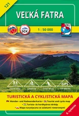
SPORTS  Hiking hiking maps Veľká Fatra 1:50 000 - 8 vydanie
.jpg)
Veľká Fatra 1:50 000 - 8 vydanie

View Full-Size Image
ACTION PRICE
Product description
Tourist map of Veľká Fatra 1:50 000 - 8th edition The map has undergone a complete detailed update of each location by local investigation personally by the staff of VKÚ Harmanec, s.r.o. Hiking routes with time data were updated in cooperation with the Slovak Tourist Club and cycling routes were updated in cooperation with the Slovak Cycling Club. The map contains updated routes for winter hiking and important landmarks.
Features:
- Includes a "WGS-84" geographic grid display (1 minute interval) for use with GPS instruments.
- The terrain of the map is shaded, with contours at a scale of 1:50 000 - 20 m.
- The text section, which is part of the map, also contains extended tourist information.
- Explanatory notes in five languages make the map universal for foreign tourists.
- It is stored in a practical plastic container.
Parameters
Features:
- Includes a "WGS-84" geographic grid display (1 minute interval) for use with GPS instruments.
- The terrain of the map is shaded, with contours at a scale of 1:50 000 - 20 m.
- The text section, which is part of the map, also contains extended tourist information.
- Explanatory notes in five languages make the map universal for foreign tourists.
- It is stored in a practical plastic container.
Video
Question on product
Bargain packages
You can also find similar products here:
Your price: 5,60 €
7,00 €
Save 20 %
Availability
Usually ships in: In stock

EXPRESS DELIVERY via GLS and Packeta
VERIFIED SHOP more than 12 years of skills
GUARANTEED the lowest prices
Výmena tovaru zdarma pre oblečenie a obuv nad 160 €
Pri objednávke oblečenia a obuvi, s hodnotou viac ako 160 € ti poskytneme výmenu tovaru zdarma a veľmi rýchlo.
CUSTOMER SERVICE we are here for you
Customer service we are here for you
Ohľadom tohto produktu ti poradí: Patrik 0917 225 882
You can also find similar products here:
Related
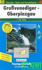
Tourist map 1:50T - Großvenediger Oberpinzgau
 9,99 €
7,99 €
Save 20 %
9,99 €
7,99 €
Save 20 %
9,99 €
7,99 €
Save 20 %
ACTION PRICE
Availability
Usually ships in: In stock
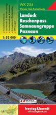
Tourist map 1:50T-Landeck Reschenpass Samnaungruppe Paznaun
 9,99 €
7,99 €
Save 20 %
9,99 €
7,99 €
Save 20 %
9,99 €
7,99 €
Save 20 %
ACTION PRICE
Availability
Usually ships in: In stock
Recently viewed
Veľká Fatra 1:50 000 - 8 vydanie
Tourist map of Veľká Fatra 1:50 000 - 8th edition The map has undergone a complete detailed update of each location by local investigation personally by the staff of VKÚ Harmanec, s.r.o.
 7,00 €
5,60 €
Save 20 %
7,00 €
5,60 €
Save 20 %
7,00 €
5,60 €
Save 20 %
ACTION PRICE
Availability
Usually ships in: In stock
Subscribe to our newsletter and keep up with the latest offers and trends
Five reasons to shop at ADAMSPORT.STORE
|
Express delivery |
Verified shop |
Guaranteed |
Customer service |
Our local store |


Contact us
Store adress:
Adam Sport, s.r.o.
Bystrická cesta 5649/4B
034 01
Ružomberok
Slovakia
adamsport@adamsport.store

VAT: 45881553
VAT ID: SK2023122321
Share your opinion with others
Add reply to comment: